
| Location Details | |||
|---|---|---|---|
| Country | Bangladesh | Latitude | 22.24972 |
| Province / District | Chittagong | Longitude | 91.81333 |
| Town or City (Closest) |
Chittagong 10 NM N South of Chittagong City |
Elevation (ft and m) | 12 ft / 4 m |
| Airfield Name | Shah Amanat International Airport | IATA and ICAO Codes | CGP / VGEG |
| Open From (hours) | 00.00 | Open To (hours) | 00.00 |
Introduction and Overview
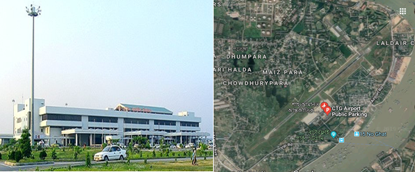
Shah Amanat International Airport (SAIA) is the second-largest international airport in Bangladesh after Shahjalal International Airport in Dhaka. The airport is operated and maintained by the Civil Aviation Authority of Bangladesh. It is used by the Bangladesh Air Force as a part of 'BAF Zahurul Haq Base'. It was renamed on 2 April 2005 after an Islamic saint, Shah Amanat. It is capable of annually handling approx. 2 million passengers and 10,000 MTs of cargo. SAIA also serves as a base to Arirang Flying School. The airport is in the Patenga area of the city, 20 kilometres west from the city's main commercial hub, GEC Circle and 18.5 km south of the city's railway station on the north bank of the Karnaphuli River.
The airfield was built in the early 1940s under the British rule. Known as Chattogram Airfield during World War II, it was used as a combat airfield, as well as a supply point and photographic reconnaissance base by the United States Army Air Forces' Tenth Air Force during the Burma Campaign 1944-1945. After liberation initially it was mainly used for connecting Dhaka and Chattogram. But in the mid-1990s Bangladesh Biman started it’s international flights to Bangkok, Dubai and all other major Gulf cities and it officially became an international airport.
In March 1998, a major renovation and expansion began, which ended in December 2000. CAAB received financial assistance from the Japan International Cooperation Agency for the US$51.57 million upgrade. The upgrade modernised the terminal with new and better seats, more check-in counters, better security equipment and other facilities. The Air Traffic Control tower received new hi-tech equipment such as 3D radar. The runway, taxiways and the tarmac were expanded and improved. After the upgrade, aircraft such as the Boeing 747-400 or the Airbus A 340 can land easily. The Airport is ICAO certified in 2005.
Contact details of the Airport:
|
Name & Address |
Contact Names & Email |
Telephone & Fax |
|---|---|---|
|
Shah Amanat International Airport, Chattogram |
Name: Wg Cdr Sarwar-e- Zaman Title: Airport Manager Email: apmctg@caab.gov.bd |
Tel: 880 31 2500900 (off) |
General Information of SAIA
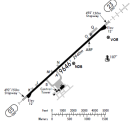
Briefly Runway and Apron
|
Runway & Lighting
|
Single Backtrack Runway 05/23 2940m X 45m |
|
|---|---|---|
|
PCN 66 F/C/X/T |
||
|
Runway end turning pads 120m X 80m |
||
|
Precision approach CAT1 lights on RWY 23 |
||
|
Simple approach lights RWY 05 |
||
|
CAT-1 ILS System for RWY23 |
||
|
Apron |
Single Apron 750’ X 430’ with head of stand roadway surrounded by soft grassy areas |
|
|
Four main parking stands are nose in – push out configuration. |
||
|
Standard parking: 2x747-400 + 1x DC10+1 xA380 |
||
|
Dense parking: Standard Parking + 4AN12’s |
||
|
Two taxiway entrances / exits |
||
|
Lighting masts at the head of each stand. |
||
|
Two fixed air bridges which are capable of handling Boeing 747-400 sized A/C. |
Terminal building
The airport's sole 20,000 m2 passenger terminal is divided into two parts: International and Domestic with a boarding bridge in each. The International part of the terminal is larger than the Domestic one due to higher number of passengers. The building is divided into two floors: The lower floor is used for checking in, boarding or getting off small planes and receiving luggage. The upper floor is used for boarding or getting off large planes only. The 2nd Terminal Building is in the active consideration of authority.
Following are some dotted points of the existing Terminal:
- Modern concrete arrival / departure terminal capable of handling approx 2 million passenger per annum.
- 4 departure lounges with suitable seating areas capable of holding 1500 people in total.
- 16 check-in desks.
- 1 domestic arrivals hall and 1 large international arrivals hall.
- Overall size of the terminal building is 18,600m².
- Total number of Bays- 10 (6-Old and 4-New).
Control Tower
The Air Traffic Control Tower is 50 meters west of the airport terminal. This single ATC tower controlling both commercial and military operations. It has a clear view of the tarmac and taxiways but is far from the runway. Heavy rain or fog can make it difficult for controllers to see planes taking off or landing. At present total 16 civilian ATC staff supplemented by BAF controllers work here. They provide 24-hour ATC coverage; however, normal operations are 18-20-hour days. No traffic flow restrictions.
|
Contact : Senior Air Traffic Control Officer, Phone : +88 0312 500 954 and +88 0312 500 982 |
Taxiway and Tarmac
The airport has 2 taxiways, Alpha and Bravo, that directly leads to the tarmac (or aircraft parking zone) from the runway. The tarmac can accommodate a maximum of four aircraft; two wide-body Boeing 747-400s, a wide-body McDonnell Douglas DC-10 and a narrow-body Airbus A320 can be parked there at once. The airport has two boarding bridges and two passenger steps. The parking points are usually empty as most of the planes that arrive there take off soon after. A small civil plane hangar belonging to Biman is available but is rarely used.
The Bangladesh Military has a parking zone and two plane hangars east of the runway. The Bangladesh Air Force store a few planes here, which have direct access to the runway.
Runway Details
|
Airport ID |
Dimensions |
Surface |
PCN |
ILS |
|---|---|---|---|---|
|
05/23 |
9646 x 150 feet 2940 x 46 meters |
PART CONCRETE, PART ASPHALT, OR PART BITUMEN-BOUND MACADAM. |
66 FCXT |
YES |
|
Description |
Runway 05 |
Runway 23 |
|---|---|---|
|
Surface |
Part Concrete, Part Asphalt, or Part Bitumen-Bound Macadam. |
Part Concrete, Part Asphalt, or Part Bitumen-Bound Macadam. |
|
True Heading |
004.80 |
228.0 |
|
Latitude |
22.240814 (22° 14' 26.93" N) |
22.258406 (22° 15' 30.26" N) |
|
Longitude |
91.802653 (091° 48' 09.55" E) |
91.823919 (091° 49' 26.11" E) |
|
Elevation |
12.0 feet (4 meters) |
12.0 feet (4 meters) |
|
Slope |
0.0° |
0.0° |
|
Landing Distance |
9646 feet (2940 meters) |
9646 feet (2940 meters) |
|
Takeoff Distance |
10840 feet (3304 meters) |
9846 feet (3001 meters) |
|
Overrun Length |
1194 feet (364 meters) |
200 feet (61 meters) |
|
Overrun Surface |
Asphalt |
Asphalt |
|
Lighting System |
A4 -PAPI-Portable Lights |
A1-PAPI-Portable Lights |
Airport Data
|
Geographical and Administration Data |
||
|---|---|---|
|
1. |
ARP* coordinates and site at AD* |
221525.28N, 0914919.95E; in the runway |
|
2. |
Distance and direction from city |
10 NM (18.5 km) south of City railway station |
|
3. |
AD elevation/reference temperature |
Elev: 12ft / T: 32degree C (April) |
|
4. |
Magnetic variation |
55' West in 1985 (Annual change negligible) |
|
5. |
Type of traffic permitted |
IFR/VFR |
|
Rescue and Fire Fighting Services |
||
|
1. |
AD category for fire fighting: |
Required category 7, available category 7. |
|
2. |
Rescue equipment available: |
Available to meet the ICAO requirement for category 7. |
|
3. |
Disable Aircraft Removal |
Nil (But in crisis assistance will be provided from Dhaka) |
|
4. |
Seasonal Availability Clearing |
The airport is available for all seasons. Side strips become unusable during monsoon. There is no requirement for clearing. |
|
Surface Movement Guidance, Control System and Markings |
||
|---|---|---|
|
1. |
Use of aircraft stand ID signs, TWY guidelines and visual docking/ parking guidance system of aircraft stands |
Taxiing guidance signs at all intersections with TWY and RWY at all holding positions, Guidelines at apron, Nose-in guidance at airport stands. |
|
2. |
RWY and TWY markings and LGT |
RWY: 05/23. white, omni-directional. |
|
Aerodrome Obstacles |
|||||
|---|---|---|---|---|---|
|
In approach/Take-off areas |
In circling area |
||||
|
RWY affected |
Obstacle type; |
Position |
Marking/ Light |
Remarks |
Obstacles in the circling area at aerodrome are shown on the instrument approach charts and page VGEG AD 2-9 of AIP. All obstruction are provided with day marking and obstruction lighting where necessary and feasible. |
|
23 |
Hill |
064 deg M FM THR RWY 23 |
No |
River Karnaphully flows around RWY23. Masts of ships and boats may constitute mibile obstructions on approach. |
|
|
Meteorological Information Provided |
||
|---|---|---|
|
1. |
Associated Met office |
Shah Amanat Intl. (VGEG) |
|
2. |
Hours of service |
H24 |
|
3. |
Office responsible for TAF preparation and Periods of validity |
Shah Amanat Intl. (VGEG); 12 |
|
4. |
Type of landing forecast Interval of issuance |
TREND; 1/2 hourly |
|
5. |
Briefing/consultation provide |
P, D, T |
|
6. |
Flight documentation and Languages used |
C, PL; English |
|
7. |
Charts and other information available for briefing or consultation |
S,U |
|
8. |
ATS units provided with information |
TWR |
|
9. |
Additional information |
Tel: 880-31-740788, |
|
Declared Distances |
|||||
|---|---|---|---|---|---|
|
RWY |
TORA (m) |
TODA (m) |
ASDA (m) |
LDA (m) |
Remarks |
|
05 |
2940 |
2940 |
3000 |
2940 |
nil |
|
23 |
2940 |
2940 |
3000 |
2940 |
nil |
|
RWY: Runway; TORA: Take-off Run Available; TODA: Take-off Distance Available; ASDA: Accelerate-Stop Distance Available; LDA: Landing Distance Available. |
|||||
|
Approach and runway lighting |
|||||||||
|---|---|---|---|---|---|---|---|---|---|
|
RWY designator |
APCH LGT type |
THR LGT color WBAR |
VASIS (MEHT) PAPI |
TDZ LGT LEN |
RWY centre line LGT |
RWY edge LGT LEN, spacing, color INTST |
RWY end LGT color WBAR |
SWY LGT |
Remark |
|
05 |
Simple approach lighting system |
Green |
3 deg |
nil |
nil |
Last 2000 ft amber rest white omnidirectional with intensity 20%, 40%, 60%, 80%, 100% |
Red unidirectional Green omnidirectional |
nil |
nil |
|
23 |
Simple approach lighting system |
Green |
3 deg |
nil |
nil |
Last 2000 ft amber rest white omnidirectional with intensity 20%, 40%, 60%, 80%, 100% |
Red unidirectional Green omnidirectional |
nil |
nil |
|
Other Lighting, Secondary Power Supply |
|||
|---|---|---|---|
|
1. |
ABN/IBN location, characteristics and hours of operation |
ABN: Over new water tank Altn FLG W G EV 5 Sec (Hours: HN and IMC) |
|
|
2. |
LDI location and LGT Anemometer location and LGT |
Nil |
|
|
3. |
TWY edge and centre line lighting |
Edge: Blue edge lgts for all TWYs |
|
|
4. |
Secondary Power Supply/ Switchover time |
During main power supply failure, Automatic standby generator power supply available within 11 seconds. Kerosene flares availabl. |
|
|
5. |
Remarks |
APRON LIGTHS: available |
|
|
ATS Airspace |
|||
|
Designation |
Chattogram Control Zone |
||
|
1. |
Lateral limits |
A circle of 25 NM radius central on Chattogram VOR (221527.85N 0914938.93E). |
|
|
2. |
Vertical limits |
FL 145 AGL |
|
|
3. |
Airspace |
C |
|
|
4. |
ATS unit call sign/ Language |
Chattogram Tower/ English |
|
|
5. |
Transition altitude |
4000 ft |
|
|
Designation |
Air Traffic Zone (ATZ) |
||
|
1. |
Lateral limits |
ATZ is oval shaped area joining outer tangents of 5 NM (9 km) radius circles centered at the runway centre and both ends of runway |
|
|
2. |
Vertical limits |
4000 ft ALT |
|
|
3. |
Airspace |
C |
|
|
4. |
ATS unit call sign/ Language |
Chattogram Tower/ English |
|
|
5. |
Transition altitude |
4000 ft |
|
|
ATS Communication Facilities |
||||
|---|---|---|---|---|
|
Service designator |
Call sign |
Frequency |
Hours of operation |
Remarks |
|
Aerodrome and Approach Control (Non-Radar) |
Chattogram Tower |
118.7 MHz |
HO* |
Emergency frequency 121.5 MHz; EM: A3 |
|
Surface Control Movement (SMC) |
Chattogram Tower |
112.8 MHz |
HO |
EM: A3 |
|
DATIS |
Chattogram Information |
127.6 MHz |
HO |
|
|
*HO: Service available to meet operational requirements |
||||
|
Radio Navigation and Landing Aids |
|||||
|---|---|---|---|---|---|
|
Type |
Ident |
Freq |
OpHr |
Coordinates |
Remarks |
|
DVOR |
CTG |
113.4 MHz |
H24 |
221527.85N |
373m from THR RWY23. EM:A2 |
|
DME |
|
1168 MHz |
H24 |
221527.85N |
Collocated with DVOR, Elev of Antenna 45ft AMSL, EM:P9 |
|
NDB |
EG |
287 kHz |
H24 |
221504.61N |
2205m fm THR RWY23, EM:A0/A2 |
|
ILS/LLZ |
ICG |
110.5 MHz |
HO |
|
144 deg MAG, 550m FM THR RWY 32, EM:A2 |
|
ILS/GP |
|
332.6 MHz |
HO |
|
Slope: 3 deg, 130 m off-set East, 300 m inward fm RWY 14, RDH 51.57 ft, EM:A3 |
|
TDME |
|
1003 MHz |
HO |
|
Collocated with GP |
|
MM |
|
75 MHz |
HO |
|
049 deg MAG, 905m FM THR RWY 23 |
|
HO: Service available to meet operational requirements |
|||||
Airfield Details
|
Customs |
Yes |
JET A-1 fuel |
Yes |
|---|---|---|---|
|
Immigration |
Yes |
AVGAS 100 |
Yes |
|
Terminal Building |
Yes |
Single Point Refueling |
Yes |
|
Passenger Terminal |
Yes |
Air Starter Units |
Yes |
|
Cargo terminal |
No |
Ground Power (mobile) |
Yes |
|
Pax transport to airfield |
No |
Crash Crew |
Yes |
|
Control Tower |
Yes |
Aircraft Support Services |
Yes |
|
Weather Facilities |
Yes |
Latrine Servicing |
Yes |
|
Catering Services |
No |
Fire Fighting |
Yes |
|
Base Operating Room |
No |
Fire Fighting Category (ICAO) |
Category: VII |
|
Airport Radar |
No |
Fire Fighting Equipment |
Yes |
|
NDB |
Yes |
De-icing Equipment |
No |
|
VOR |
Yes |
IFR Procedures |
Yes |
|
ILS |
Yes |
Runway Lights |
Yes |
|
Approach Lights |
Yes |
Parking Ramp Lighting |
Yes |
Other information for passengers
|
First Aid |
For sick or injured passengers first aid crews from CAAB provide free of cost treatment during watch hours. |
|---|---|
|
Banking System |
Banking facility for foreign currency exchange booth is available in the international terminal building. |
|
Duty Free Shop |
Private and Bangladesh Parjatan Corporation are operating duty free shop for the passenger(s). |
|
Hotel Booking |
Hotel booking booth is available for the passenger(s) for hotel booking. |
|
Pure Drinking Water |
Pure drinking water is available for the passenger(s). |
|
Prayer Room |
Prayer room is available for the passenger(s) |
|
CCTV Camera |
Close circuit camera for the security of the passenger (s). |
|
Wi-Fi |
Free Wi-Fi is available for the passenger(s). |
|
FIDS |
Flight Information Display System is available for the passenger/visitor to know the arrival and departure time of the flights |
|
Luggage Wrapping |
Luggage wrapping facility is available for the passengers to pack their luggage. |
Helicopter Pad
The Airport is also used by military aircraft for their normal operations and training purpose. They use Also helicopters beside other aircraft. In time of emergency this airport can very well be used for any types of helicopters. There is enough facilities for operating number of helicopters in any emergency situation.
Airport Performance (last 5 years)
|
Year |
Cargo Handled (MT) |
Aircraft Movements (000) |
Passenger Handled (in Lac) |
||
|---|---|---|---|---|---|
|
Export |
Import |
Domestic |
International |
||
|
2018 |
2281.72 |
5636.35 |
14238 |
7754 |
16.93 |
|
2017 |
2991.35 |
3270.22 |
13523 |
8034 |
15.27 |
|
2016 |
3741.13 |
2439.71 |
14599 |
6736 |
12.51 |
|
2015 |
2652.07 |
10,680.24 |
12557 |
6677 |
11.71 |
|
2014 |
1553.29 |
13,760.75 |
10999 |
6087 |
10.66 |
Disaster Scenarios at the Airport
|
Cyclones |
|
|---|---|
|
Earthquakes |
|
|
Flooding |
|
Airport Customs
- There is a good setup of Customs authority to take care of the Export/Import formalities through this airport.
- They are fully automated with their universal ASYCUDA World.
- Waivers can / will be issued by the central government via NDMA.
- Large customs area exists within the terminal building.
- Customs officers available 24 hours.
- Sufficient customs staff available for 24 hour operations, however, additional customs staff can be drafted in from the nearby port authority.
- The customs process and policies are under the jurisdiction of the Board of Revenue, not the Civil Aviation Authority.
|
Contact: Assistant Commissioner of Customs, Tel: +88 31 800 423 |
Immigration
- Immigration officers available 24 hours a day.
- An emergency immigration procedure exists in the national disaster plan which allows for speedy processing of foreign aid workers. This plan will be enforced at the request of the NDMA.
- Sufficient immigration officials are present to perform 24 hour operations, however, if required, additional immigration staff can be drafted from the nearby port authority.
|
Contacts: Assistant Police Commissioner (Immigration), Phone: +88 171 337 3272 |
Cargo Handling Procedure and Storage Facilities
Cargo Handling
Biman Bangladesh Airlines is the authorised and responsible agent for handling all Cargo in regard to SAIA. As the airport is not hanlding huge cargo at the moment their arrangements for such operation is also at medium scale. Some times some private operators are also authorised and issued licence by CAAB to operate the cargo and other GSE matters in specific cases. How ever for conducting the present operations smoothly BB has following GSE equipment is place.
GSE Equipment
| Equipment Type | Qty |
|---|---|
| Towing Tractor | 08 |
| Push Cart | 02 |
| Start Cart | 02 |
| Ground Power Unit | 03 |
| Container Pallet Loader (Can’t load at height of Double Decker) | 03 |
| Flash Cart | 02 |
| Water Cart | 02 |
| AC Van (unserviceable) | 01 |
| Passenger Step | 04 |
| Forklift | 02 |
| Belt Loader | 05 |
| Ramp Coach | 02 |
| Catering High Loader | 01 |
| Tow Bar | 05 |
| Forklift | 01 |
Storage Facilities
Warehouse: Though there is no Cargo Village as such like Hazrat Shahjalal International Airport, but this airport has workable facilities. They have 2 warehouses connected to the aircraft apron by tarmac road. One concrete floor space of 2700 m² capable of accommodating 100 MT of freight which is divided into 9 caged areas of various sizes. All scanned cargo is stored in this warehouse from where cargo is delivered on completion of all necessary formalities. The newly built cargo shed is of approx. 3000 m2 capable of accommodating 150 MT freight. This shed is still underutilized. Cargo received from Aircraft are stored here primarily and later shifted to the delivery warehouse for necessary checking and completion of formalities. Landside loading / offloading area providing capacity to park 36 trucks simultaneously.
Cargo operations are owned and controlled by Bangladesh Biman. May be mentioned that Catering facility is available within the landside truck parking area.
Cold Chain: Two large cold storage rooms (12’x10’ and 12’x11’) are in operation which can be accessed from the inside of the warehouse. They maintain temperature between -40 to 100 C to be used as Cold chain for preserving medicine and special items.
Airside loading area, partially covered, providing capability to load / offload 12 trucks simultaneously.
Temporary Warehousing Arrangements
- Though 2 Permanent Cargo warehouse are available, but in time of crisis there is ample opportunity to make temporary arrangements for storing cargo at the airport premise and nearby places.
- The GSE storage and maintenance facility could be made available within 1-2hours for storage and breakdown of air cargo. Approximate size is 800m² hard covered area plus an additional 1600m² of open concrete hard standing. GSE area is accessible by one airside / landside gate and tarmac road to apron.
- A large Red Cross warehouse is available within 1km of the airport facility and can be utilized during disaster relief operations.
- A large factory warehouse is available within 1km of the airport facility and can be utilized during disaster relief operations.
- Warehousing options exists at both the BAF and Naval military installations within 2km of the airport (BAF located on airport site).
- Lot of open space available on the eitherside of warehouses which can be used for cargo storage errecting temporary sheds (open concrete space, usually used for truck operations).
- Office space is available within the GSE building to facilitate distribution administration activity.
| Despite Ltd warehouse capacity on the airport site, a number of larger warehousing options exist close to the airport facility. This gives Chattogram airport greater flexibility in terms of cargo accommodation and relief aid distribution. |
Development Projects
Future Development Works:
- Construction of parallel taxiway
- Extension of existing runway.
- Construction of two Boarding Bridge
- Construction of Cargo Warehouse.
Fuelling Arrangements
Padma Oil Company under the supervision of Bangladesh Petroleum Corporation (BPC) is solely responsible for providing fuel to all kinds of Aircraft at Shah Aamanat International Airport. Arrangements are there to support a full fledget International Airport. The depot is co-located within Half a Km of the airport. Few salient features of this Aviation fuel provider are below:
|
Sl |
Description |
Arrangement |
|---|---|---|
|
1 |
Type of Fuel |
Jet A1 and Avgas |
|
2 |
Tanks with Capacity |
3 Tanks (each 4,22,500 Ltr capacity) |
|
3 |
Requisition for Fuel |
Written requisition with Payment be placed in advance, if prior contaract is not signed. |
|
4 |
Hydrant lines |
The whole airport area is covered under the fuel Hydrant network. At present points are being used and 10 new Hydrant points are being installed. |
|
5 |
Fueling arrangement |
Normally Fueling is done by following refuellers:
|
|
6 |
Filters |
Total-6 (2 for receiving, 2 for Loading and 2 for Hydrants) |
|
7 |
Consumption/Capacity |
Daily approx 210-215 MT/ Capacity 5 Lac Ltrs daily |
|
8 |
Price of Jet A1 |
BDT 75/00 and $ 0.72 per ltr |
|
9 |
AVGAS |
Normally 30-35 Barrels are kept in reserve against monthly consumption of 15-20 Barrels Monthly |
|
10 |
Manpower |
Manager-1, Asst Manager-2, Officers-5, Other staff-19, Casual-12, Ansar-6 |
|
Contact Details |
Depot Manager Cell: 01777703403 & Duty Officer Cell: 01777703309 |
Security Arrangements
- A large security presence exists on the airport with a significant number of airport security personnel.
- Security personnel are under the control of the airport manager.
- A dedicated police station exists within 1km of the airport.
- All access points are guarded by security personnel.
- Due to proximity of BAF military instillation, a large military presence can be drafted in to support policing if required.
- Temporary passes can be issued to airside workers within 30 minutes upon the directive of the NDMA.
- X-Ray screening for both passengers and cargo is in use.
|
Contact: Airport Security Officer, Phone: +88 312 500 941 ext. 212 / 270 |
For information on Bangladesh Shah Amanat International Airport contact details, please see the following link:
4.5 Bangladesh Airport Contact List
Information on some aviation service providers can be found at: AZ Freight information on Bangladesh
