
Key port information can also be found at: Maritime Database information on Port of Lome
Port Overview
Niger is a landlocked country and therefore relies on neighbouring countries ports – Cotonou, Benin; Lomé, Togo; and Tema, Ghana are mostly used. Lomé is a free port, or free zone, which is strategically located in the sense that I can reach several West African capitals within a day. It is the only natural deep-water port on the West African coast that can potentially accommodate third generation ships. The port authority’s long term goal is to exploit this advantage to become the maritime hub for container trans-shipment in West Africa.
Construction is underway of a third pier which is scheduled to be completed by the end of 2013. It will have a draught of 16.6 meters that will enable the port to accommodate larger vessels and triple the port’s capacity within ten years. A new terminal is also underway. The port is run by the Port Autonome de Lomé (PAL) which is a state-owned company that oversees activities at the port and performs loading and offloading of wheat, hydrocarbons and minerals.
Port website: http://www.togoport.tg/
|
Port Location and Contacts |
|
|---|---|
|
Country |
Togo |
|
Province or District |
|
|
Town or City (Closest location) with Distance (km) |
Name : Lomé Km: 0 |
|
Port's Complete Name |
Port Autonome de LOME |
|
Latitude |
6.133333 |
|
Longitude |
1.283333 |
|
Managing Company or Port Authority (If more than one operator, break down by area of operation) |
Port Autonome de Lomé (PAL) |
|
Management Contact Person |
Direction Générale : 227 08 78 – Standard : 227 47 442 – Niger representation : +227 20 74 03 26 / +227 96 96 48 73 |
|
Closest Airport and Frequent Airlines to / from International Destinations |
Airport Name: Lomé-Tokoin Airport (Gnassingbé Eyadéma International Airport) Airlines: Air Burkina, Air Côte d’Ivoire, Air France, Air Mali, ASKY Airlines, Benin Golf Air, Brussels Airlines, Ceiba Intercontinental Airlines, Ethiopian Airlines, Royal Air Maroc, Toumaï Air Tchad. |
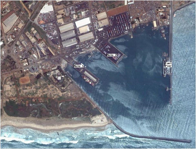
Port Picture
|
Map reference number and Description |
Length (m) |
Draught (m) |
|
|---|---|---|---|
|
1 |
General cargo (1) |
150 |
6 |
|
1 |
General cargo (2) |
150 |
10 |
|
1 |
General cargo (3) |
150 |
10 |
|
1 |
General cargo (4) |
150 |
8.5 |
|
2 |
Containers (5) |
230 |
11 |
|
2 |
Containers (6) |
210 |
12 |
|
3 |
Mineral berth |
190 |
12 |
|
Fuel pier |
Tanker berth |
187 |
14 |
|
|
New pier [under construction] |
1 050 (five berths) |
16.6 |
Description and Contacts of Key Companies
Handling of cargo is split between the port authorities and private companies. The Port Authority maintains handling of clinker; wheat; hydrocarbons and coasters. Container handling is performed by SE2M and Manuport, while conventional cargo handling is covered by SE3M and Manuport. SE2M and SEM3 are part of the Bolloré Africa Logistics group while Manuport is part of the Necotrans group. NITRA handles transit from the port to Niger, and Niger’s representative at the port is CNUT (conseil Nigéerien des Utilisateurs des Transports publics). Cotecna Inspection handles a mobile scanner and controls containers and vehicles in cooperation with the Customs office.
Among other companies operating in the port are Togo Terminal, a Container Terminal operator; Lome Multipurpose Terminal, a conventional terminal operator; SDV Togo, a Shipping and transit agency; SAGA Togo, a shipping and transit agency; STCM, a Shipping agency; GETMA and MSC, shipping companies; SDV-Damco, forwarding agent.
4.2.4 Niger Port and Waterways Company Contact List
Port Performance
The Lomé port handled about 8.2 million metric tonnes in 2011, this figure represents import, export and transit. Container traffic has seen the biggest development with a growth of 60 % in traffic since 2005. The growth rate has flattened over the last three year and the number of vessel calls has seen little evolution. The port of Lomé has nonetheless undertaken construction of a third pier and a new terminal which will double the port’s current capacity over five years and triple it over ten years. The maximum channel draft is 14 meters, which will be increased to 16.6 meters when the third pier is completed. This should allow vessels up to 7 000 TEU to dock at the port. The port has seen up to 63 hours in average waiting time in 2009 for general cargo and 24 hours for container vessels, 2011. Supposedly congestion has since dropped significantly since the introduction of fixed berthing windows and Lomé can boast a productivity of close to 35 movements per hour/ship which is among the best in Africa. The clearing speed of imported goods is less than impressive as it takes a minimum of four to five days. The current container terminal system is also criticised for being inconveniently located which entails additional handling. The port roads are in a very poor state. A final concern for the port is the presence of pirates in the region which notably threaten oil tankers.
|
Seasonal Constraints |
Yes / No |
From <month> to <month> |
|---|---|---|
|
Rainy Season |
Yes |
June to September |
|
Major Import Campaigns |
No |
n/a |
|
Other |
n/a | n/a |
|
Handling Figures |
Year 2005 |
Year 2006 |
Year 2007 |
Year 2008 |
Year 2009 |
Year 2010 |
Year 2011 |
Year 2012 |
|---|---|---|---|---|---|---|---|---|
|
Vessel Calls |
1 075 |
1 043 |
1 092 |
1 092 |
1 166 |
1 175 |
1 150 |
n/a |
|
Container Traffic (TEUs) |
204 614 |
215 898 |
237 891 |
296 109 |
354 480 |
339 853 |
350 000 |
n/a |
|
Handling Figures Bulk and Break Bulk |
Year 2009 |
Year 2010 |
Year 2011 |
|---|---|---|---|
|
Bulk (Million MT) |
2.5 ≈35 % |
3.1 ≈38.7 % |
3.3 ≈ 40 % |
|
Break bulk (Million MT) |
0.7 ≈10 % |
0.8 ≈10.4 % |
0.8 ≈ 10 % |
| Container Traffic (Million MT) |
4.1 ≈55 % |
4.1 ≈50.9 % |
4.1 ≈ 50 % |
Discharge Rates and Terminal Handling Charges
http://www.togoport.net/togoport/index.php?option=com_docman&task=doc_download&gid=3&Itemid=134
Berthing Specifications
|
Type of Berth |
Quantity |
Length (m) |
Maximum Draft (m) |
|---|---|---|---|
|
Conventional Berth |
4 |
150 |
6 – 6 – 8.5 – 10 |
|
Container Berth |
2 |
210 – 230 |
12 |
|
Silo Berth |
0 |
n/a | n/a |
|
Berthing Tugs |
Yes | ||
|
Water Barges |
Yes |
The port of Lomé has about 1 752 meters of berth which allow between eight and ten ships at the same time. For the moment there are two piers, one for general cargo and one for container handling. There is also docking for fuel and minerals and a dock for fishing vessels. Pier 1 is 336.5 meters long and 72 meters wide with four docking places. It rests on cement pillars which allow free movement of water under the pier and is designated to handle general cargo. Pier 2 is 250 meters long and 140 meters wide, it rests on a solid concrete foundation and can fit two container vessels at the same time. It is also the location for the multi-purpose container terminal. The oil jetty is 250 meters while the mineral dock measures in at 210 metres. The fishing dock is 60 meters and can accommodate up to nine trawlers.
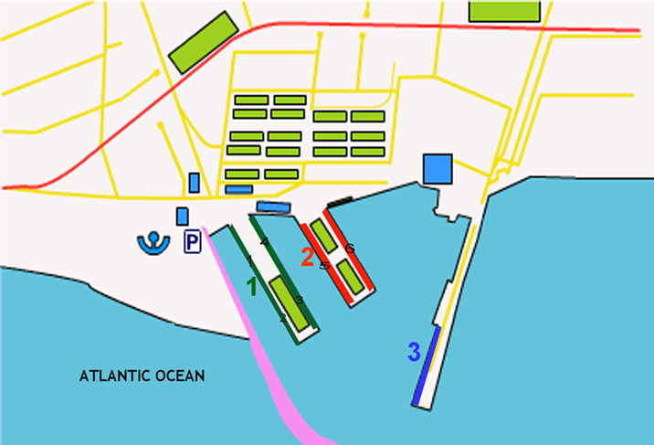
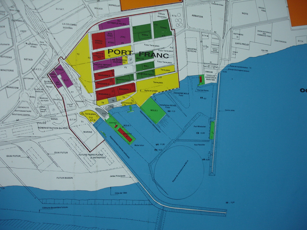
A third pier is under construction and is planned to be finished by the end of 2013. This will add five berths totalling 450 meters of dockside and is to have a draught of 16 meters which will allow for larger vessels. The pier is to be equipped with four gantries that will enable the port to operate on vessels with at least 17 rows of containers. The container storage area is also under expansion and the addition of 24 RTGs is in the plans. The placement for the pier can be seen in the layout below.
General Cargo Handling Berths
|
Cargo Type |
Berth Identification |
|---|---|
|
Imports - Bagged Cargo |
1-4 |
|
Exports - Bagged Cargo |
1-4 |
|
Imports and Exports - RoRo |
5-6 |
|
Other Imports – Mineral and hydrocarbons |
Fuel and mineral berth |
Port Handling Equipment
The port equipment is managed privately?
Port equipment is managed privately with the exception of handling of hydrocarbons and minerals which is handled by the port authority. Container handling, at pier 2, is carried out by SE2M and Manuport while conventional handling at pier 1 is covered by SE3M and Manuport.
|
Equipment |
Available (Yes / No) |
Total Quantity and Capacity Available |
Comments on Current Condition and Actual Usage |
|---|---|---|---|
|
Dockside Crane |
Yes |
2 |
Four STS gantries are planned at new berth. |
|
Container Gantries |
Yes |
2 |
|
|
Mobile Cranes |
Yes |
Quantity: 4 Capacity: 104 T |
Panamax cranes, two more are ordered. |
|
Reachstacker |
Yes |
Quantity: 23 Capacity: 45 T |
TOS = Oscar |
|
RoRo Tugmaster (w/ Trailer) |
Yes |
n/a | n/a |
|
Grain Elevator w/ Bagging Machines |
No |
n/a | n/a |
|
Transtainer |
Yes |
4 |
24 RTGs are planned at the new berth. |
|
Forklifts |
Yes |
Quantity: 32 Capacity: 2 to 16 T |
n/a |
Container Facilities
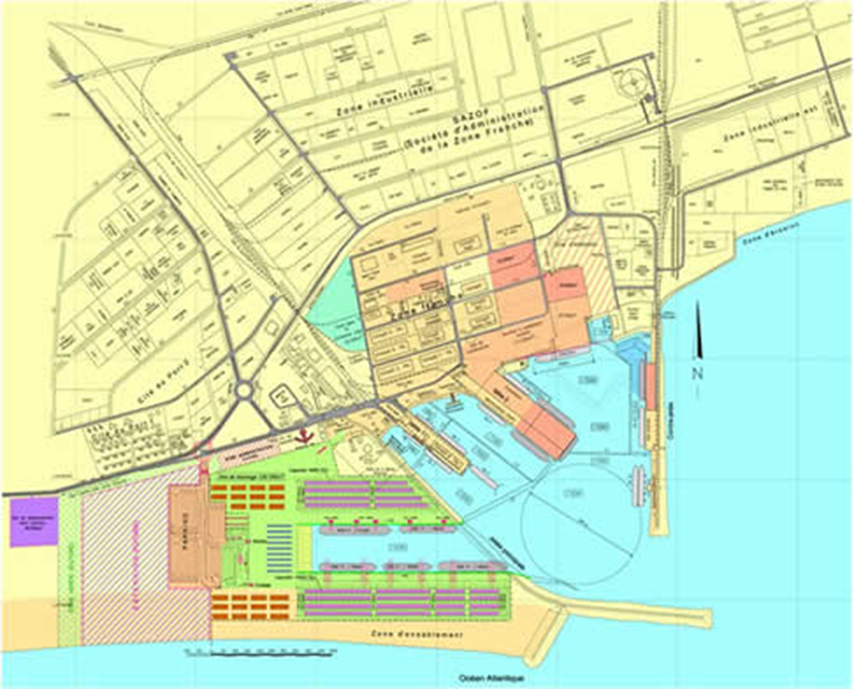
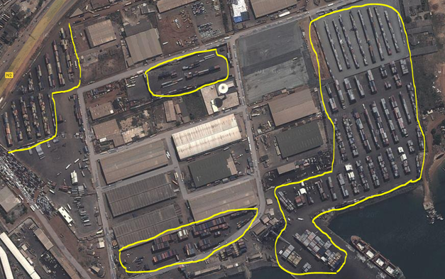
The container storage area covers about 90 000 square meters and corresponds with the yellow areas in the layout and picture below.
|
Facilities |
20 ft |
40 ft |
|---|---|---|
|
Container Facilities Available |
Yes |
Yes |
|
Container Freight Station (CFS) |
Yes |
Yes |
|
Refrigerated Container Stations |
Yes |
Yes |
|
Other Capacity Details |
||
|
Daily Take Off Capacity (Containers per day) |
900 |
|
|
Number of Reefer Stations (connection points) |
100 |
|
|
Emergency Take-off Capacity (Give an indication) |
1 500 |
|
|
Off take capacity of gang shift (in Containers per shift) |
300 |
n/a |
Customs Guidance
The port of Lomé is a free port which means that handling and transferring of cargo can take place within the port areaThe custom clearing for transit involves nineteen steps which should normally take 1 415 minutes or about three working days. However, the process is subject to recurrent delays that may add up 1 535 minutes or about 3.2 working days – totalling in at 6.2 working days. Around four to five working days are generally to be expected. The reason for delays may be due to understaffing at the customs office, further the customs-release computer system is prone to failures. A detailed overview of the customs clearance process and steps to clear containers for transit can be found at page 31-33 and 81-89 in the West Africa Trade Hub Technical Report #47 accessible at http://www.watradehub.com/sites/default/files/resourcefiles/apr12/jan-2012-rev-final-corridor-ii-lome-ouaga-transport-and-logistics-costs-study.pdf. See also the Customs Information section of the LCA:
Terminal Information
Multipurpose Terminal
A multipurpose facility is available and operated by Bolloré African Logistics. Another terminal is under construction in connection with the third pier. RoRo facilities are available.
Main Storage Terminal
There are four warehouses of 7 500 square meters, labelled as “magasin C-F” in red in the layout above. Warehouse A on the pier measures at 5 000 squaremeters, while the B warehouse is used for fish. Six warehouses are designated for transit to Burkina Faso, Mali and Niger – dark green in the layout. In total there is about 115 000 square meters of storage available.
|
Storage Type |
Number of Storage Facilities |
Area (square meters) |
|---|---|---|
|
Bagged Cargo |
10 |
115 000 |
|
Refrigerated Cargo |
n/a | n/a |
|
General Cargo |
Open air |
200 000 |
Stevedoring
Stevedoring activities are mostly handled by private companies where SE2M and Manuport handles container traffic at pier 2 while SE3M and Manuport handles conventional cargo at pier 1. The Port Authority of Lomé maintains handling of hydrocarbons and minerals which takes place at the fuel and minerals pier. Pier 2 is set up to handle both vertical off-loading and horizontal off-loading (Ro-Ro). Stevedoring activities at the port comprises manual labour and operation of equipment for every step from offloading, storage, packing, stripping of containers and loading of trucks. Packing can be performed both at port and in facilities in the city.
Hinterland Information
Containers may be transported directly, but are generally stripped and loaded on to trucks (60-70%). Containers that are stripped are moved to a designated area of the port where, under customs surveillance, contents are manually offloaded. Due to equipment insufficiencies this procedure often experiences delays especially if the handling company has a ship to load or off-load.
Port Security
Security at the port complies with ISPS standards and the responsibility for security has been outsourced to an American private company. A team called “the Bees” patrol the area and keeps the gates. Entry is restricted to those carrying magnetic ID-cards and cars with pre-approved clearance. Surveillance cameras are installed and there is a mobile Gantry HVC scanner available to scan cargo. The American Coast Guard has inspected the port on a couple of occasions without indicating serious flaws. The port is currently in the process of applying for ISO certification for security.
Pirates in the area are well armed, violent and dangerous. Attacks can occur at anchorages and off the coast and usually at night. Some attacks resulted in the vessel being hijacked for several days where the vessel was ransacked and part cargo stolen (gas oil). Attacks have increased the over the last years.
|
Security |
||
|---|---|---|
|
ISPS Compliant (Yes / No) |
Yes |
|
|
Current ISPS Level |
1 |
Level 1 = Normal, Level 2 = Heightened, Level 3 = Exceptional |
|
Police Boats |
||
|
Fire Engines |
1 |
