
Port Overview
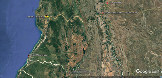
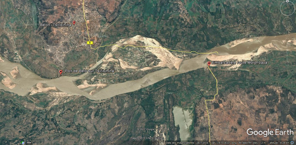
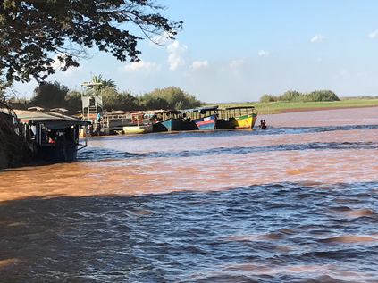
The port of Belo sur Tsiribihina is the terminal point on the Tsiribihina River.
The main function of this port is to be the end point for the tourist boats that descend the Tsibihina from Miandrivaso and the arrival for the vehicles using the ferry to come from Morondava.
Due to the good condition of the road coming from Morondava, this port is not used for the supply of the city but the surrounding villages come here to purchase and commerce with motor boats.
While this port is well known in the region, it remains undeveloped, there is no wharf or other infrastructure, but APMF is on site to control and supervise the port activities.
Key port information may also be found at: http://www.maritime-database.com
|
Port Location and Contact |
|
|---|---|
|
Country |
Madagascar |
|
Province or District |
Toliara |
|
Nearest Town or City with Distance from Port |
Belo sur Tsirbihina 2 km |
|
Port's Complete Name |
Port of Belo sur Tsiribihina |
|
Latitude |
-19.713060° |
|
Longitude |
44.540171° |
|
Managing Company or Port Authority
|
APMF |
|
Management Contact Person |
Responsable de port: Mr Paul +261 34 988 05 82 |
|
Nearest Airport and Airlines with Frequent International Arrivals/Departures |
Morondava Airport: 170km Air Madagascar: Daily flight to Antananarivo |
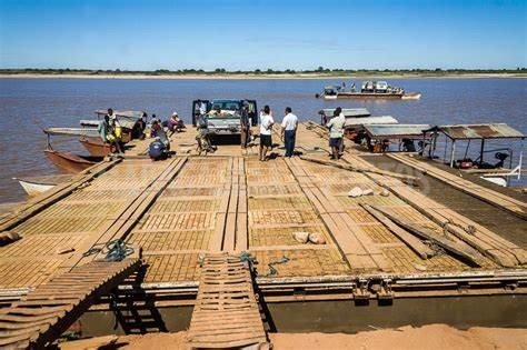
Port Picture
Port of Belo sur Tsiribihina
Embarcadère route de Morondava
Ferry to access Belo sur Tsiribihina from Morondava
Description and Contacts of Key Companies
No company registered at that port
For more information on port contacts, please see the following link: 4.4 Port and Waterways Companies Contact List.
Port Performance
No data available
|
Seasonal Constraints |
||
|---|---|---|
|
|
Occurs |
Time Frame |
|
Rainy Season |
Yes |
December to June |
|
Major Import Campaigns |
No |
N/A |
|
Other Comments |
Between January and March there is a phenomenon called Asar, the level of water increases and greatly impairs river transport. |
|
Discharge Rates and Terminal Handling Charges
See point 2.1 Port Assessment for the reference price list
Berthing Specifications
|
Type of Berth |
Quantity |
Length (m) |
Maximum Draft (m) |
Comments |
|---|---|---|---|---|
|
Water Barges |
1 |
200 m |
2.5 m |
|
General Cargo Handling Berths
|
Cargo Type |
Berth Identification |
|---|---|
|
Imports - Bagged Cargo |
All goods received / sent form the ground |
|
Exports - Bagged Cargo |
All goods received / sent form the ground |
|
Imports and Exports - RoRo |
All goods received / sent form the ground |
|
Other Imports |
All goods received / sent form the ground |
Port Handling Equipment
No equipment available
Is the port equipment managed by the government or privately? Government APMF
Container Facilities
No container facilities
Customs Guidance
No customs available on sit
Terminal Information
No terminal no storage available on site
Stevedoring
Basic manutention from the ground. No company available. Work has to be requested on site with daily workers.
Hinterland Information
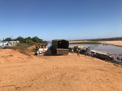
To access to Belo sur Tsiribihina, there is a 170 kms sand track in quite good condition, daily used by cars, trucks and public transport (can be done in 3h30).
At the end of the road, there are small BAC to cross the Tsiribihina River (crossing takes around 15min).
Port Security
|
Security |
|
|---|---|
|
ISPS Compliant |
No |
|
Current ISPS Level |
N/A |
|
Police Boats |
No |
|
Fire Engines |
No |
